
By Futurist Thomas Frey
The Commute That Changed Everything
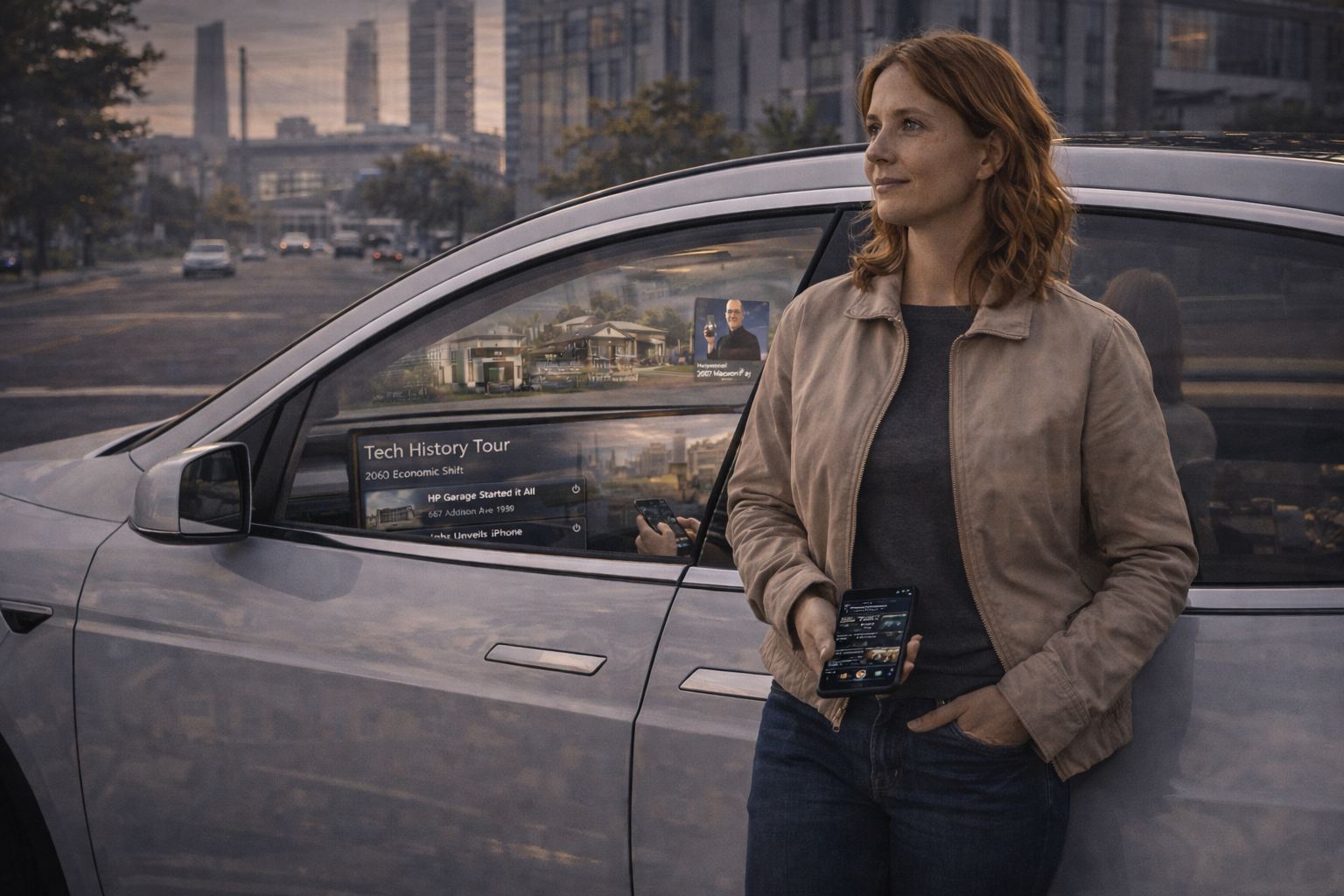
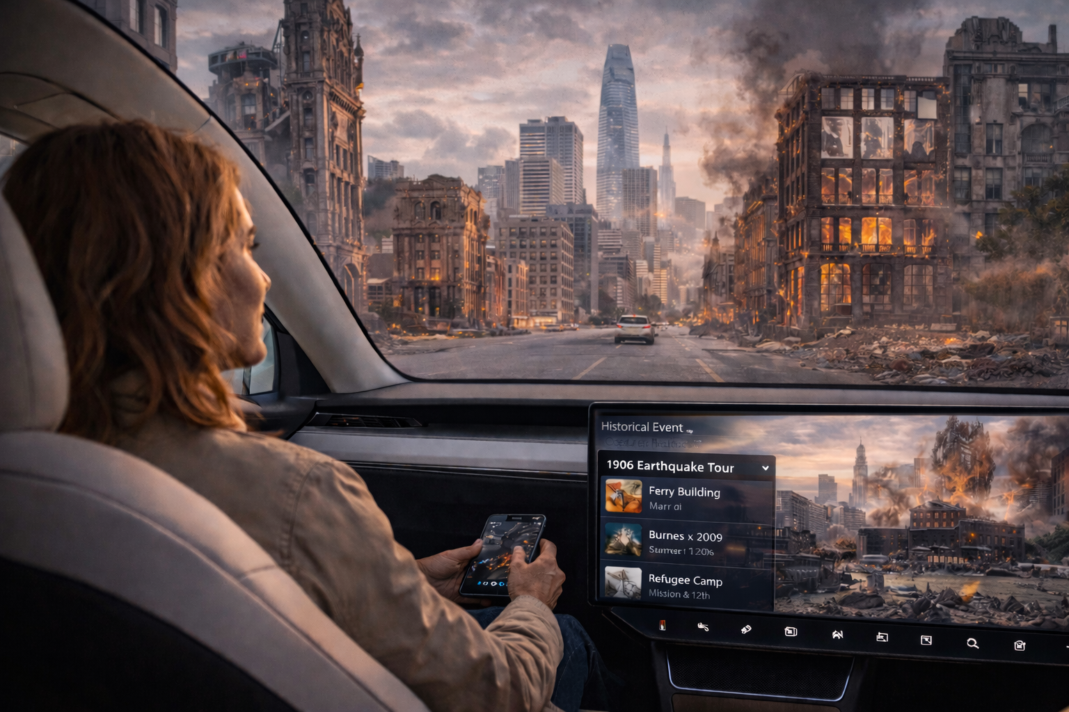
It’s Tuesday morning, 2031. Jennifer Mitchell climbs into her autonomous Tesla for the daily commute from Oakland to San Francisco. But instead of scrolling through email or zoning out to a podcast, she taps her phone and selects “1906 Earthquake Tour.”
The car’s audio system comes alive with the voice of a narrator as they cross the Bay Bridge.
“Just ahead, beneath these waters, lies the wreckage of the ferry terminal that collapsed during the quake. Over there—” the system highlights a point on her window with a subtle AR overlay “—that’s where the fire started that would burn for three days, consuming more of the city than the earthquake itself.”
As they enter the city, the overlay intensifies. Ghostly outlines of destroyed buildings appear on her screen, superimposed over the modern skyline. Historical photos fade in and out. Survivor testimonies play as they pass locations where people huddled in refugee camps.
Fifteen minutes later, Jennifer switches to “Tech History Tour.” Now the same streets tell a different story: the garage where Hewlett and Packard started their company, the hotel where Steve Jobs unveiled the iPhone, the coffee shop where Instagram was conceived.
Same geography. Infinite narratives.
This is the future of driving. Or rather, the future of being driven.
The Fundamental Shift
For over a century, driving demanded attention. You watched the road. You navigated. You avoided collisions. The landscape was scenery at best, ignored at worst.
Autonomous vehicles change everything. Suddenly, the journey itself becomes available real estate. Time that was consumed by driving becomes time to experience, to learn, to engage with place in entirely new ways.
The technology is almost absurdly simple: GPS location + audio narration + AR overlays + massive databases of geotagged content. But the implications are profound.
Every drive becomes a potential tour. Every commute becomes an opportunity to rediscover familiar geography through unfamiliar lenses.
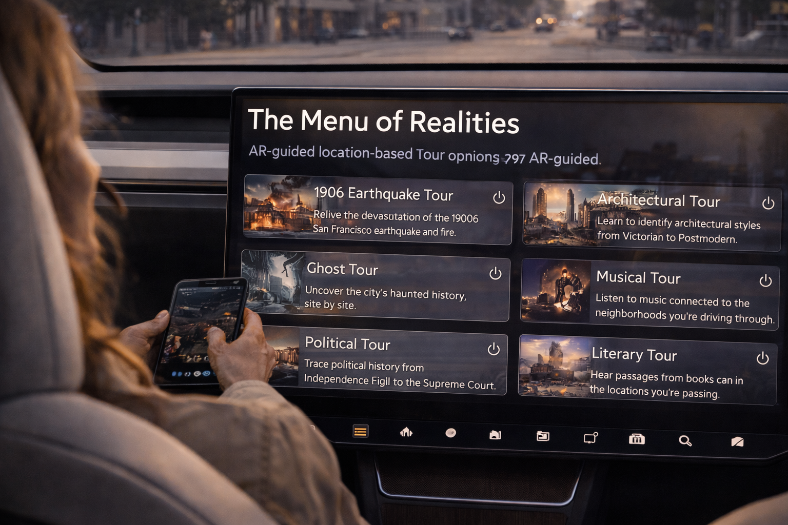
The Menu of Realities
The geography-overlay apps emerging in the early 2030s offer an astonishing range of perspectives on the same physical space:
**Historical Tours** operate like traditional audio guides, but with precision impossible for human tour guides. As you pass a specific intersection, you hear about the event that happened there—not approximately there, but *exactly* there, down to GPS coordinates. The system knows which building burned in 1889, which street corner hosted a famous speech, which parking lot was once a theater where a president was shot.
**Architectural Tours** transform every drive into a design education. The app identifies buildings by style—Victorian, Art Deco, Brutalist, Postmodern—and explains the principles behind each. It shows you hidden details: the gargoyles you’d miss at 40 mph, the repurposed industrial architecture, the way one building deliberately echoes another three blocks away.
**Ghost Tours** overlay every city’s dark history. Murders, hauntings, disasters, scandals. The autonomous vehicle becomes a hearse, slowly cruising past sites of tragedy while narrators describe what happened. Macabre? Absolutely. Popular? Enormously. By 2033, ghost tours are the third-most-downloaded tour category after historical and food tours.
**Musical Tours** play songs connected to locations as you pass them. Drive through Liverpool and hear Beatles tracks recorded in the studios you’re passing. Cross the Mississippi Delta and listen to blues musicians singing about the exact cotton fields outside your window. Pass the Apollo Theater and hear the artists who performed there, in chronological order if you want, or shuffled by mood.
**Political Tours** trace power through geography. Constitutional Convention debates play as you drive past Independence Hall. Supreme Court decisions narrate as you pass the courthouse where cases originated. Campaign speeches from 1960, 1980, 2008, 2024 play at the exact locations where they were delivered. You can watch political geography shift in real-time: which neighborhoods voted which way, how district boundaries changed, where protests happened and why.
**Literary Tours** read passages from books set in the locations you’re passing. Drive through Dublin and hear Ulysses narrated street by street. Cross the Golden Gate Bridge while Kerouac describes that exact view. Pass through Hannibal, Missouri while Tom Sawyer’s adventures unfold in the precise locations Twain imagined them.
But those are just the conventional tours. The truly revolutionary categories are the ones that don’t describe what *was*, but what *might have been* or *might be*.
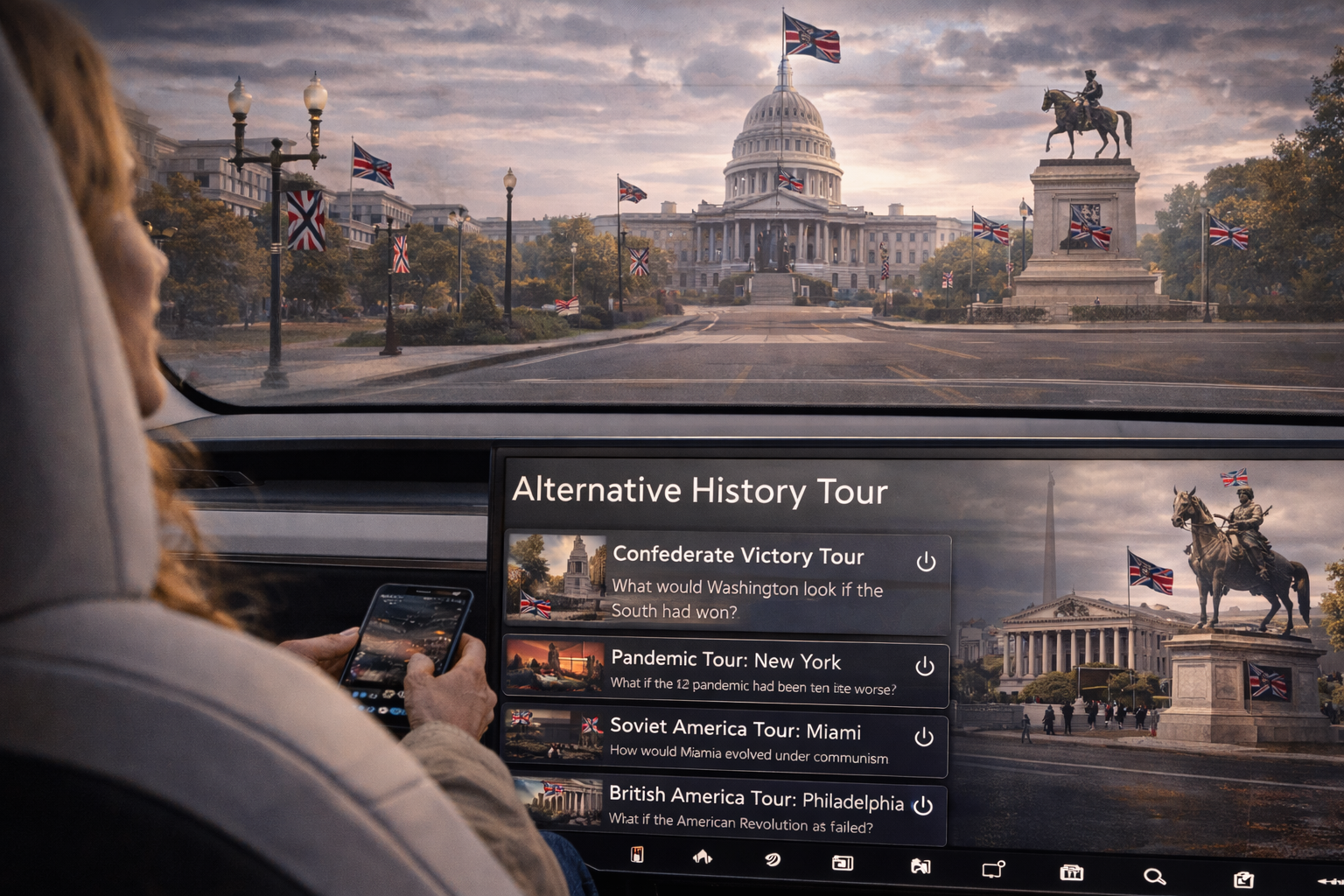
Alternative History Tours
This is where it gets strange and compelling.
The “Confederate Victory Tour” of Washington DC shows you what the capital might look like if the South had won the Civil War. Buildings are rendered differently. Street names change. The AR overlay depicts monuments that were never built, celebrating leaders who lost.
Controversial? Absolutely. Educational? Undeniably. By experiencing an alternative timeline overlaid on reality, you understand how contingent history actually is. How close we came to different outcomes. How geography might have been reimagined under different political circumstances.
The “Soviet America Tour” shows American cities as they might have developed under communist planning. The “British America Tour” imagines a timeline where the Revolution failed. The “Pandemic Tour” shows cities as they might have evolved if COVID-19 had been far more deadly.
These aren’t meant to advocate for these outcomes. They’re thought experiments. Ways of understanding the forces that shaped actual history by imagining the forces that might have shaped different histories.
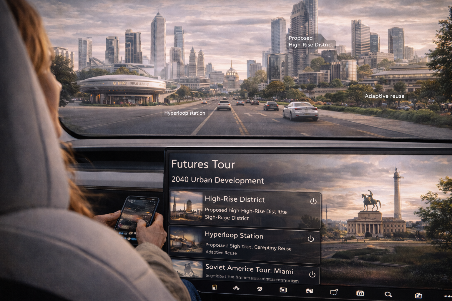
Futures Tours
Even more fascinating are the futures overlays.
Select “2040 Urban Development Tour” and watch your city transform. The AR overlay shows proposed high-rise districts, relocated industrial zones, and planned infrastructure expansions. You can see which neighborhoods are slated for redevelopment, which historic buildings will be preserved, where new commercial centers are planned.
The “2045 Transit Tour” shows proposed transit networks, both realistic and fantastical. Hyperloop stations that may or may not ever be built. Expanded subway lines. Gondola systems. You can see multiple competing visions for the same city, compare them, understand the trade-offs.
The “2050 Architecture Tour” renders the skyline as city planners imagine it. Taller buildings. Different materials. Adaptive reuse of current structures. You drive through a city that doesn’t exist yet but might.
Most provocatively, the “2060 Automation Tour” shows which buildings, businesses, and entire neighborhoods might disappear as automation renders their economic function obsolete. Which malls will be converted to housing. Which office towers will become vertical farms. Which industrial zones will be reclaimed as parkland.
These tours force uncomfortable questions. They make the future feel less abstract. When you can see exactly which landmark will be demolished for a new development, urban planning becomes visceral rather than statistical.
databases merge to turn transportation into a time machine.
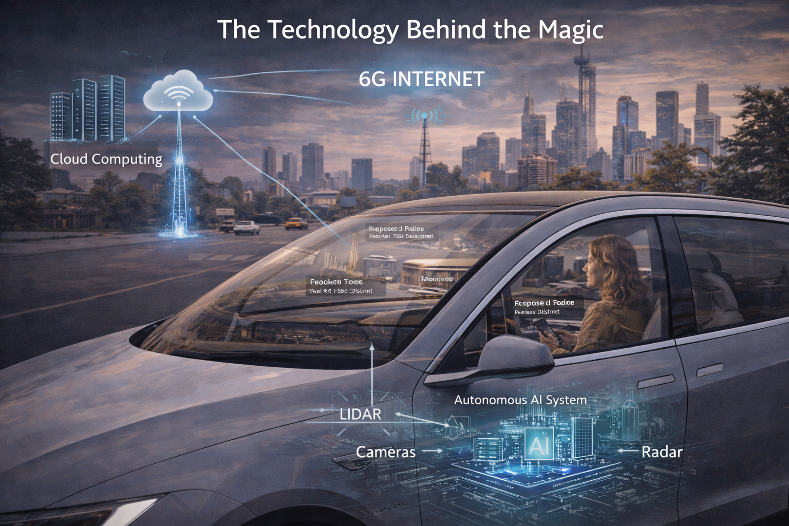
The Technology Behind the Magic
Making this work requires several converging technologies:
**Precise GPS** down to centimeter-level accuracy, so the system knows exactly where you are and what you’re looking at.
**Massive geotagged databases** containing millions of historical events, architectural details, musical moments, political speeches, literary references, all tied to specific coordinates.
**AI narration** that can generate contextual explanations on the fly, adapting to your interests and prior knowledge. The system learns whether you want deep detail or surface overview, academic precision or entertaining storytelling.
**AR integration** that seamlessly overlays digital content onto the physical world you’re seeing through the car’s windows or your phone.
**Crowdsourced content** from historians, architects, musicians, local experts who contribute their knowledge to specific locations.
None of this technology is particularly exotic. Most of it exists in 2025. What’s missing is the integration layer—the platform that brings it all together into seamless, location-aware experiences.
That integration is happening now. By 2028, the first comprehensive geography-overlay platforms will launch. By 2032, they’ll be standard features in autonomous vehicles.
The Economics of Attention
Here’s what makes this inevitable: autonomous vehicle manufacturers need to justify the premium cost of their vehicles. The car itself becomes a commodity—one self-driving sedan is functionally identical to another. The differentiation comes from the *experience* of being in the car.
Tesla, Waymo, Mercedes, and others will compete on the quality of their in-vehicle entertainment and education systems. Geography-overlay tours are perfect for this. They’re engaging, educational, endlessly customizable, and they make the time spent in the vehicle feel valuable rather than wasted.
The tours themselves become new media categories. People will subscribe to premium tour content the way they currently subscribe to Netflix or Spotify. Historians will create tours. Musicians will curate them. Cities will commission official tours to promote tourism.
The economics work because the content is reusable. A historical tour of Boston created once can be experienced by millions of riders over decades. The more people use it, the more valuable the platform becomes.
The Cultural Implications
This changes how we relate to place.
Currently, most people experience geography as utilitarian space. You drive through neighborhoods to get somewhere else. You pass buildings without knowing their stories. You inhabit a city without understanding its layers.
Geography-overlay tours make place into narrative. They reveal that every location is actually hundreds of locations, depending on which lens you use. The intersection you pass daily was a battlefield, a jazz club, a speakeasy, a protest site. It will be a flood zone, a transit hub, a memorial.
This has profound educational implications. Children growing up with these tours will develop spatial-historical thinking that previous generations lacked. They’ll understand that history isn’t abstract—it happened *here*. The future isn’t distant—it will happen *here*.
It also democratizes expertise. You don’t need to hire a tour guide or join a group. You don’t need to read a guidebook or take a class. The knowledge comes to you, contextualized by your precise location, at the exact moment it’s relevant.
The Darkness
Of course, this power can be abused.
Authoritarian governments could create mandatory tours that present sanitized, propagandistic versions of history. Corporations could sponsor tours that reframe urban development as benevolent when it was actually displacement. Alternative history tours could normalize extremist ideologies by making them seem plausible.
The same technology that makes learning accessible makes manipulation easier. When AR overlays can literally rewrite what you see through your window, the line between education and indoctrination blurs.
This will require vigilance. We’ll need open-source tours alongside commercial ones. Fact-checking systems. Multiple perspectives on contested histories. The same kind of media literacy we need for social media, now applied to geography.
The Morning Commute, Reimagined
Back to Jennifer Mitchell, driving through San Francisco. Or rather, being driven.
This morning she experienced the 1906 earthquake. Tomorrow she might toggle to the Gold Rush era, or the Summer of Love, or the Loma Prieta earthquake, or the first dot-com boom, or a futures tour showing what the city might look like with proposed urban development.
Same commute. Same route. Infinite experiences.
The car isn’t just transportation anymore. It’s a time machine, a classroom, a window into alternate realities. The geography hasn’t changed. But our ability to experience the layers of meaning embedded in that geography has exploded.
Every drive becomes a tour. Every passenger becomes a student of place. Every autonomous vehicle becomes a platform for understanding the infinite stories hidden in the landscape we too often ignore.
The technology is almost ready. The content is being created. The platforms are launching.
Soon, very soon, the question won’t be “Where are you going?” but “When are you going? Which history? Which future?”
The destination stays the same. The journey becomes infinite.
Related Articles:
- Augmented Reality and Cultural Heritage: https://www.mdpi.com/2076-3417/11/7/2961
- Location-Based Storytelling and Tourism: https://www.tandfonline.com/doi/full/10.1080/13683500.2023.2228002
- The Future of In-Vehicle Entertainment: https://www.mckinsey.com/industries/automotive-and-assembly/our-insights/the-future-of-mobility-is-at-our-doorstep
